About All Tours Hot Springs ToursEmbalse el Yeso ToursFrom Santiago ToursPrivate ToursWinter Tours Directions Hours & Fees
Find Tours 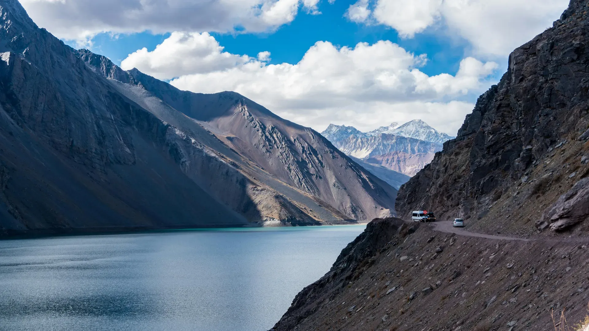
Cajon del Maipo occupies 5,000 square kilometers of the Andes mountains southeast of Santiago, Chile. The canyon holds over 600 glaciers, three active stratovolcanoes, and the primary drinking water reservoir for the metropolitan region.
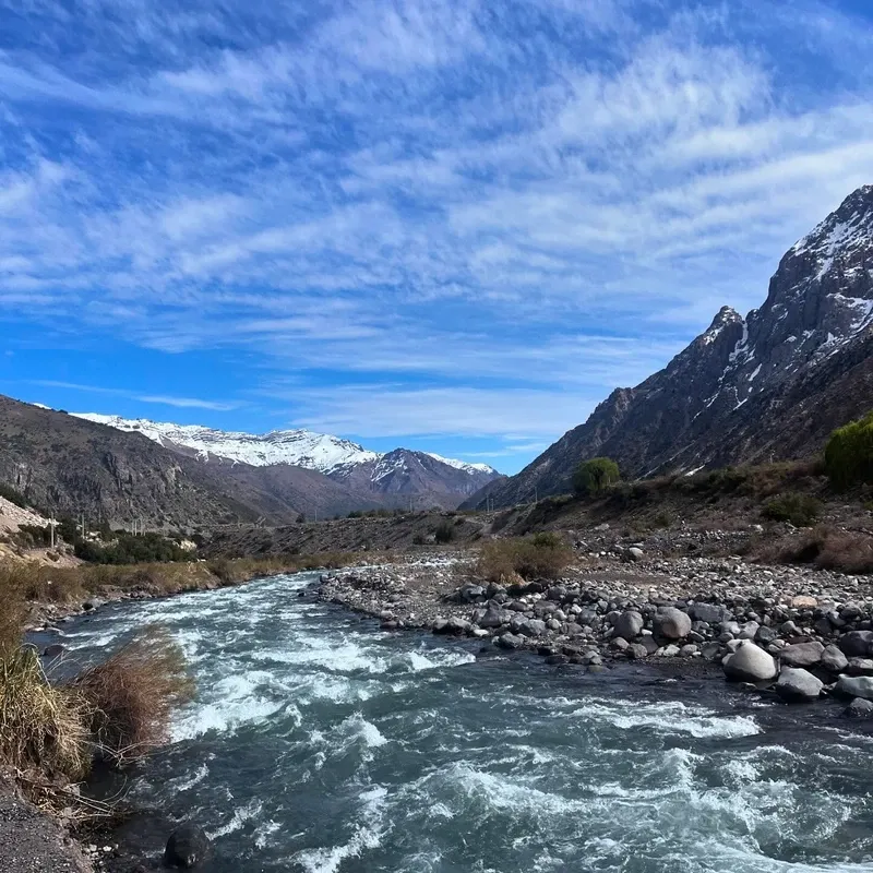
Water from the Maipo River carves a 70-kilometer trench through the Andes mountains southeast of Santiago. This 5,000-square-kilometer canyon system climbs from 600 meters at the valley floor to 6,570 meters at the Marmolejo summit. Visitors driving Route G-25 encounter sharp basalt cliffs, turquoise glacial meltwater, and active stratovolcanoes dominating the skyline. The air thins noticeably past the police checkpoint in San Gabriel, dropping temperatures by 15°C within an hour as the sun dips behind the peaks.
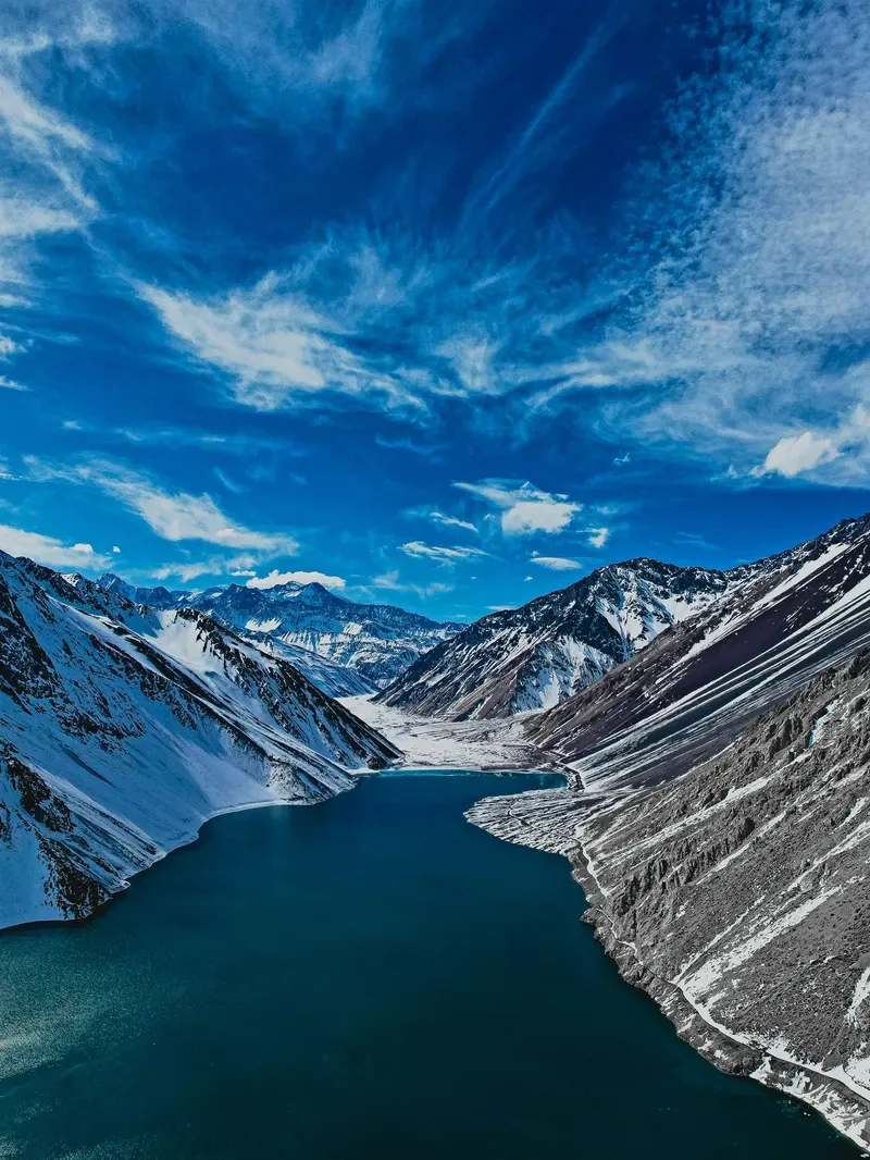
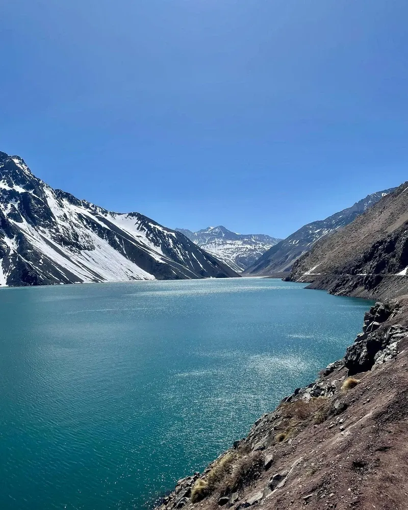
Santiago relies on this basin for daily survival. The Embalse El Yeso reservoir holds 253 million cubic meters of water, supplying the capital's drinking infrastructure through a network of high-pressure pipes and treatment facilities. Beyond utility, the canyon functions as central Chile's primary staging ground for high-altitude recreation. Class III and IV rapids churn through the lower sections near San Alfonso during the summer melt season, drawing hundreds of rafters daily. Higher up the valley, natural thermal pools like Termas Valle de Colina terrace down the mountainside. These nine basins hold mineral-dense water heated between 25°C and 55°C by deep volcanic activity.
The landscape transitions drastically as elevation increases. Lower elevations feature sclerophyllous forest and private reserves like Cascada de las Ánimas, where zip-lines cross the river gorge and horseback riders navigate narrow cliff trails. Above 2,000 meters, trees disappear entirely, replaced by tough alpine shrubs, cushion plants, and exposed scree slopes. Andean condors ride the thermal updrafts along the cliff faces, while culpeo foxes scavenge near the high-altitude campsites. The sheer scale of the rock formations dwarfs the small settlements dotting the riverbanks.
Conditions change rapidly in the high Andes. The smoothly paved Route G-25 degrades into the narrow, gravel Route G-455 near the reservoir turnoff. Rockfalls frequently block this final stretch after heavy rain, leaving vehicles stranded for hours. Winter storms between June and September bring meters of snowfall, triggering sudden road closures and dangerous whiteout conditions known locally as 'viento blanco'. Tourists must carry physical Chilean pesos, as card machines fail in the deep canyon where mobile phone service drops to absolute zero past the town of San Gabriel.
Spanish authorities established San José de Maipo on July 16, 1792, acting on a royal decree from the Governor of Chile, Ambrosio O'Higgins. The crown needed a formal settlement to manage the extraction of silver, copper, and gypsum from the surrounding mountains. Adobe structures with deep verandas formed the original grid around a central Plaza de Armas. Miners carved rudimentary trails into the rock faces, hauling ore down by mule trains that took days to reach the capital. These early, precarious routes laid the exact groundwork for the modern road network currently used by tourists. The village quickly became a vital economic engine for the colonial government.
Charles Darwin rode into the canyon in 1835 during his Beagle voyage. He documented the area's complex geology, noting marine fossils embedded in high-altitude rock layers thousands of meters above sea level. His field notes provided early, concrete evidence of tectonic uplift in the Andes. Decades later, mining operations scaled back as veins depleted, and the Chilean government shifted focus to the valley's massive water resources. The population transitioned from transient miners to permanent agricultural workers and merchants. Small-scale farming replaced industrial extraction along the riverbanks.
Engineers completed the Los Maitenes hydroelectric plant in the early 20th century. This facility harnessed the Maipo River's steep gradient to generate power for a rapidly expanding Santiago. Construction on the massive Embalse El Yeso reservoir began in 1953 and required eleven years of continuous labor. Workers dammed the Yeso River at 2,500 meters above sea level, pouring thousands of tons of concrete to create a 253-million-cubic-meter basin. This project secured the capital's water supply and inadvertently created the canyon's most photographed landmark. The reservoir completely altered the local microclimate and hydrology.
Conservation balances heavily with mass tourism today. The Chilean Geological Society declared the region the Geological Capital of Chile in 2018, recognizing its 600 glaciers and visible tectonic fault lines. High-altitude trekking now requires formal registration with the Carabineros police at the San Gabriel station to prevent disappearances. The El Morado Natural Monument enforces strict entry rules, permanently locking the gates at 12:30 PM to prevent hikers from getting caught on the San Francisco Glacier trail after dark. Rescue operations remain difficult and expensive in the upper reaches of the canyon.
Subduction of the Nazca plate beneath the South American plate dictates the extreme topography of Cajón del Maipo. The resulting tectonic friction pushes the Andes upward by millimeters each year, creating a jagged skyline dominated by three active stratovolcanoes. The San José Volcano reaches 5,856 meters, venting sulfurous gases from fissures near the Argentine border. Marmolejo stands as the southernmost 6,000-meter peak on Earth, topping out at a massive 6,570 meters. These peaks feature permanent ice caps that feed the entire valley system. The sheer verticality of the canyon walls blocks direct sunlight for much of the day in the lower sections.
Over 600 individual glaciers cling to these high-altitude slopes. The San Francisco Glacier, accessible via an 8-kilometer round-trip trek in the El Morado Natural Monument, features deep blue crevasses and a massive moraine field of shattered granite. Ice melt feeds the Maipo River system, carrying suspended glacial flour—fine rock particles ground down by moving ice. This sediment turns the Embalse El Yeso reservoir a distinct, milky turquoise. The reservoir spans a high-altitude valley at 2,500 meters, hemmed in by barren, wind-scoured peaks that block the horizon in every direction. Strong gusts whip across the water surface, creating dangerous conditions for small boats.
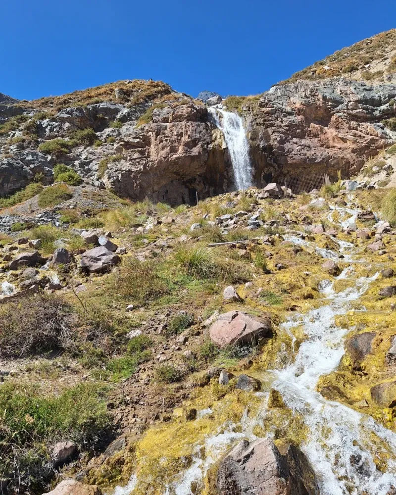
Geothermal activity surfaces violently at Termas Valle de Colina. Nine natural pools step down a steep, rocky hillside, filled with mineral-heavy water pumped directly from the earth. Temperatures hit 55°C in the top pool and cool gradually to 25°C in the lowest basin. The air smells sharply of sulfur and damp earth. Vegetation remains sparse at this elevation, limited to tough alpine shrubs and dense cushion plants that hug the ground to survive freezing night temperatures.
The physical infrastructure of the canyon reflects the harsh environment. Visitors driving the final gravel stretch of Route G-455 navigate a single-lane road cut directly into a sheer scree slope. Falling rocks present a constant hazard, and the lack of guardrails leaves a sheer drop to the river below. The terrain demands respect, punishing drivers who attempt the route in low-clearance vehicles during the winter months. Heavy rains routinely wash out entire sections of the road, requiring heavy machinery to restore access to the upper valley.
San José de Maipo retains the precise architectural footprint of an 18th-century mining hub. Single-story adobe houses with terracotta tile roofs line the streets radiating from the Plaza de Armas. Local artisans sell copper jewelry, lapis lazuli, and heavy wood carvings in the central square, maintaining trades passed down through generations of mountain residents. The town functions as the last major outpost before the wilderness, operating as a mandatory staging ground for international mountaineering expeditions attempting the 6,000-meter peaks. Climbers spend days here acclimatizing to the altitude and purchasing final provisions.
The canyon holds deep psychological importance for the seven million residents of Santiago. It provides a massive physical barrier against the smog and dense urbanization of the capital, offering immediate access to raw alpine environments just 60 kilometers away. Weekend traffic routinely clogs the two-lane Route G-25 as city dwellers drive up for traditional asados (barbecues) along the rocky riverbanks. Families spend Saturdays roasting meat over open fires, swimming in the freezing glacial runoff, and escaping the trapped heat of the Santiago basin. The river acts as a communal gathering space for people from all socioeconomic backgrounds.
Legends persist in the lower valley, blending Catholic traditions with local folklore. The decommissioned Túnel del Tinoco, a dark, 600-meter railway tunnel, contains dozens of animitas—small, house-shaped roadside shrines built by locals. Visitors leave lit candles, flowers, and handwritten offerings to Willy, a young man who died in the tunnel decades ago. Locals treat the site as a place of spiritual intervention, asking for safe passage through the mountains or giving thanks for answered prayers. The tunnel floor remains uneven and pitch-black, requiring a strong flashlight to navigate safely past the shrines.
Further up the valley, the hamlet of Baños Morales maintains a distinct, isolated mountain culture. The 40 permanent residents operate small hostels and thermal mud baths, living cut off from the main electrical grid. They rely on solar panels and diesel generators to survive the brutal winter months when snowdrifts block the only access road. This isolation fosters a strong, self-reliant community that views the canyon not as a tourist destination, but as an unforgiving home.
Over 600 individual glaciers exist within the canyon's formal boundaries.
Marmolejo stands as the southernmost mountain on Earth to exceed 6,000 meters in elevation.
Engineers poured thousands of tons of concrete to build a reservoir holding 253 million cubic meters of water.
Charles Darwin discovered high-altitude marine fossils here during his 1835 expedition.
Termas Valle de Colina features nine terraced hot springs with water temperatures reaching 55°C.
The San José Volcano vents sulfurous gases at 5,856 meters and remains geologically active.
Locals converted the abandoned 600-meter Túnel del Tinoco railway tunnel into a massive shrine complex.
It is a large Andean canyon and valley system southeast of Santiago, Chile. The area encompasses the upper basin of the Maipo River and covers approximately 5,000 square kilometers of mountainous terrain. It serves as the primary source of drinking water for the capital.
The main town, San José de Maipo, sits 45 to 60 kilometers from the Santiago city center. The drive takes about 1 hour and 15 minutes via Route G-25. Reaching deeper attractions like Embalse El Yeso requires an additional hour of driving.
A standard car handles the paved roads to San José de Maipo and San Gabriel easily during summer. A 4x4 vehicle is necessary for winter driving or navigating the unpaved, rocky final stretch of Route G-455 to the reservoir.
Visitors can experience mild altitude sickness at the reservoir and hot springs, which sit between 2,500 and 3,000 meters above sea level. Drinking water and avoiding heavy meals before ascending helps mitigate symptoms.
Independent visits are possible, but you must reserve entry in advance through the Asociación Parque Cordillera website. The gravel road to the reservoir requires careful driving due to steep drop-offs and rockfall hazards.
The park opens at 08:30 and closes at 17:30. CONAF rangers strictly prohibit visitors from starting the hike after 12:30 PM to ensure everyone returns before dark.
Pets are strictly prohibited inside protected areas like El Morado Natural Monument to prevent disease transmission to native wildlife. They are allowed in the town of San José de Maipo and some private campsites.
October through March provides stable weather and clear hiking trails. June through September brings heavy snow, which frequently closes mountain roads and restricts access to the hot springs.
Mobile networks operate reliably in San José de Maipo. Signal drops entirely once you drive past the police station in San Gabriel, leaving the upper canyon without coverage.
Cash machines are only located in San José de Maipo. Businesses further up the valley, including the hot springs and small kiosks, operate on a cash-only basis.
Browse verified tours with free cancellation and instant confirmation.
Find Tours